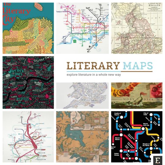
Literary periodic tables of elements are a great example of how creatively the books, authors, fictional worlds, or writing process, can be described. Literary maps are the other.
[ef-archive number=2 tag=”lists” ]
Unlike the periodic tables of everything non-chemical, the maps of literary places and events have a long tradition. They were already created in the XIX century, if not earlier.
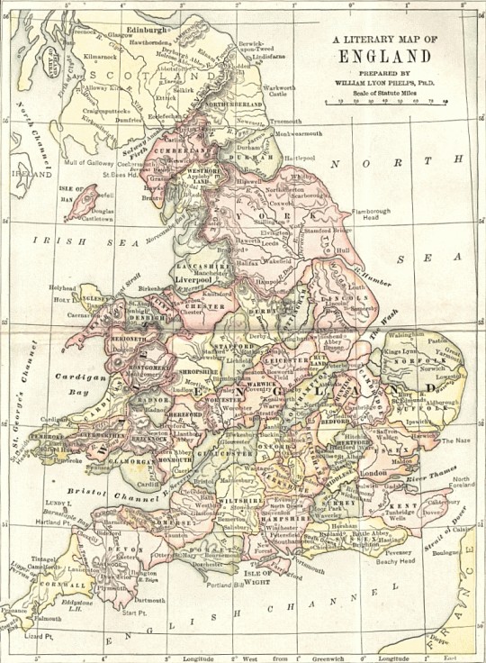
One example featured below is a literary map of England prepared by William Lyon Phelps, an American author and professor of English literature.
There are literary maps of the United States or Canada, but it’s England where this form of promoting a written word was most welcomed and admired.
We’ve collected the images in the highest possible resolution. Thanks to that you’ll be able to see how detailed these masterpieces are. Just click or tap on each image to see it in the largest possible resolution.
Some of the images can be bought as prints. Besides backlinks to creators, you will find shopping links, as well.
[ef-reco id=”90919″ title=”Read also” info=”Top article”]
17 literary maps for adventurous readers
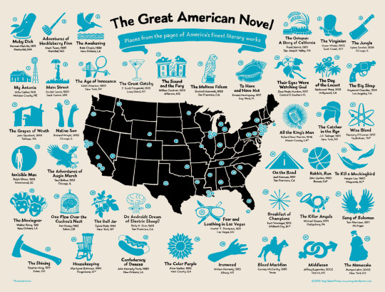
1. The Great American Novel map
This stunning illustration was drawn by artist and illustrator Mark Adams and is a fantastic way to explore America’s most valuable fiction.
The visual charts 42 famous American novels across the map of the US. Each book comes with a number that links it to a respective fictional or real-life localization.
You’ll see here the geographical references of such great books as The Awakening by Kate Chopin, Jack Kerouac On the Road, or Do Androids Dream of Electric Sheep? by Philip K. Dick.
The illustration is available as a limited edition 25 × 19 in poster. It’s screen-printed on 80 lb archival cover stock and costs $30.
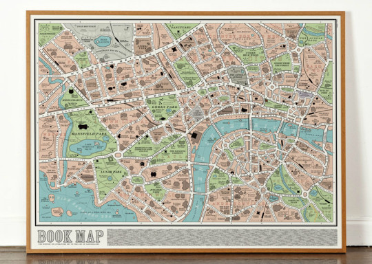
2. London book map
This fantastic street map is made up from the titles of 600 books from the history of English literature. You’ll find here such legendary names as Mansfield Park, Vanity Fair or Wuthering Heights.
The map was designed by a Manchester-based design studio Dorothy. You can buy it for £25 (80 by 60 cm).
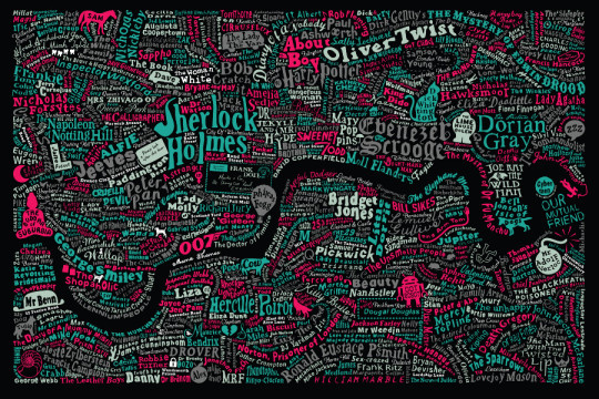
3. Literary London
This is a collaboration work of a graphic artist Dex and interior designer Anna Burles, known as Run for the Hills. The map features characters from the pages of novels, and “is swarming with famous fictional characters from London lore.”
The design is available on Culture Label in three variations: black typography on white background, white typo against black, and color typo on black. Prices from £90.
4. A literary map of England
Literary maps have a long tradition in the UK. This particular map was prepared by professor William Lyon Phelps, and published in 1899 in English Literature by William J. Long. The book is available for free from Project Gutenberg.
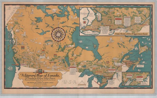
5. Deacon’s literary map of Canada
This highly detailed map was developed in 1936 in an attempt to catalog part of Canada’s rich history with the written word.
The image of the map was shared by the University of Toronto. You can get its reproduction on Etsy (unframed, 26 x 15 inches, fine paper 250gsm).
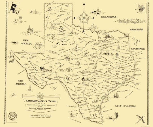
6. Literary map of Texas
An exquisite full-color reproduction of the wonderful map, issued by the Dallas Public Library in September 1955. The map shows the numerous writers of prolific works “pertaining to the unique culture of Texas.”
It’s offered by Maps of the Past, and you can buy it on Amazon, among others. Glossy satin version, 23 x 28 inches, costs $32.99.
7. Literary Britain
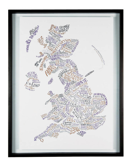
A well-recognized poster from the Literary Gift Company. Designed by Geoff Sawers, it’s a hand-lettered map of literary Britain. As much as 183 authors are featured in the original geographically-linked design.
You can purchase the map at Not on the High Street. 84 x 55cm (A1) poster printed on 200gsm recycled paper costs £15. A literary map of the USA is also available.
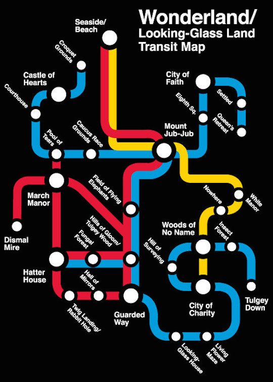
8. Looking glass land transit map
For the lovers of literary classics. Look at this subway map of Wonderland. As Maria Popova from Brain Pickings noted, it’s “juxtaposing the extreme organizational structure of a subway system with the extreme surreal chaos of the Lewis Carroll classic.”
The map is currently available on women’s and men’s t-shirts, via Etsy.
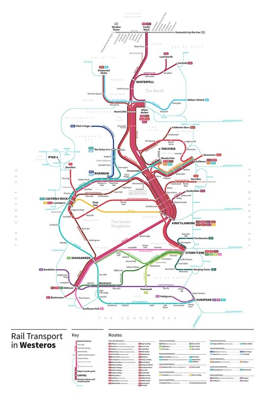
9. Rail transport in Westeros
This gorgeous map was created by New-York-based designer Michael Tyznik. It’s a fictional rail map of the fictional kingdom from the Game of Thrones.
Tyznik has included all sorts of small touches like noting certain stations that are “not in service” to coincide with plot points from the books.
Rail Transport in Westeros is available to buy on inPRNT. You can choose from three sizes. The medium, 16 × 24 inches, poster is printed on 100% cotton rag archival paper. It costs $40.
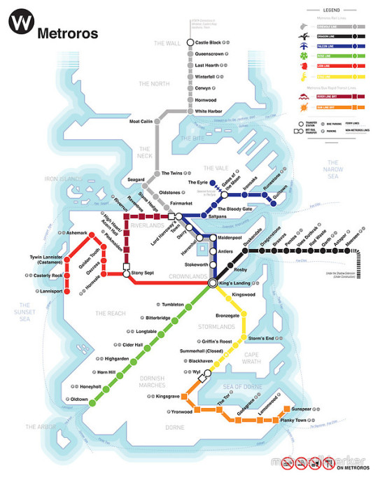
10. Metroros – a Game of Thrones subway map
Here is another Game of Thrones map. This one was actually made before the Rail Transport in Westeros.
Metroros System Map is designed by LA-based designer Mehmetikberker. You can buy it on RedBubble. It’s available as prints (many formats, including posters, cards, and canvas), t-shirts, hoodies, stickers, and cases for iPhone & iPad.
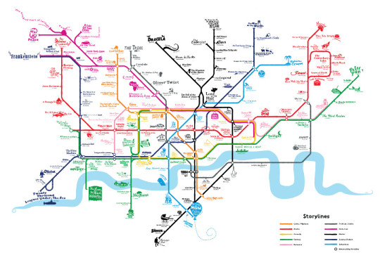
11. Storylines
An excellent artwork from Run for the Hills, again. London’s iconic underground map is “transformed into a pit-stop journey through classic styles of storytelling.”
Take a closer look: individual tube lines are turned into literary genres. The Romance line, the Science Fiction line, the Drama line – which direction are you going?
The map is available on Culture Label. The white version (shown above) costs €138.
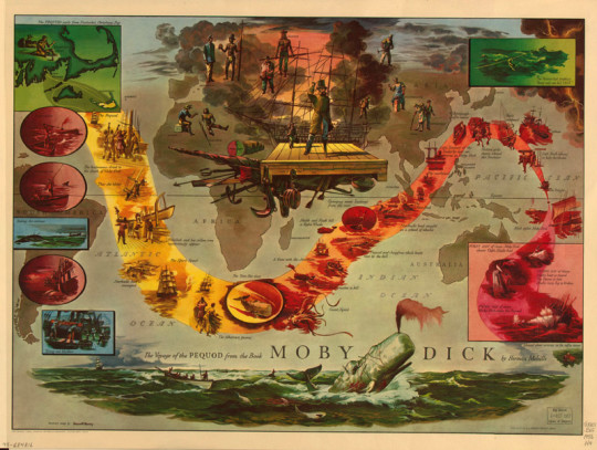
12. Moby Dick literary map
I wish there was a larger image of this map. It looks fantastic and surely there would be a lot to read and explore.
Illustrated by Everett Henry, the map is one of twelve maps produced by Harris-Seybold Company between 1953 and 1964, which are based on British and American literary classics. It’s available thanks to the Library of Congress.
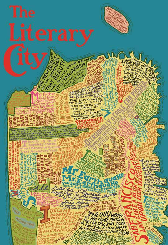
13. San Francisco – the literary city
The map was beautifully designed by Kathryn Flocken and Ben Goldman. Different city neighborhoods are denoted here by different literary quotes about the city, from authors such as Maya Angelou, Thomas Pynchon, and more.
You can’t buy it as a poster, but you can get it as a 367-piece wooden jigsaw puzzle. The finished puzzle measures 11 by 17 inches.
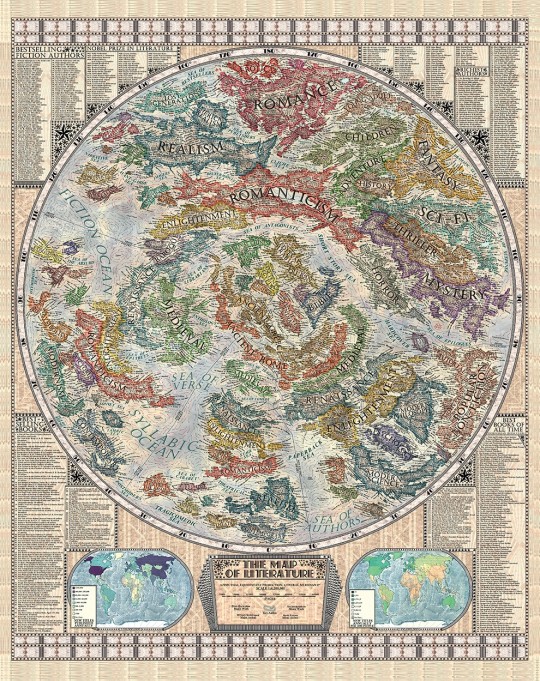
14. The Map of Literature
This vintage-looking map is the most detailed and accurate visualization of the phenomenon of literature.
The incredibly detailed drawing was created by a student from Slovakia, Martin Vargic. It visualizes how the world’s literature evolved from the ancient era to the present day.
The map has four continents: fiction, nonfiction, drama, and poetry. Countries represent different genres and periods. What’s more, the globe is surrounded by the lists, including winners of Nobel Prize in Literature, bestselling books, and richest authors.
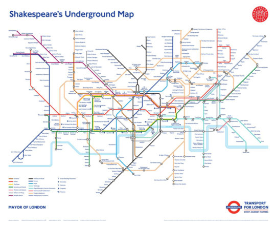
15. Shakespeare’s London Underground map
This awesome map was developed in 2016 by Transport for London in cooperation with Shakespeare’s Globe to celebrate the 400th anniversary of the death of the Bard.
All 14 lines and 367 stations in the iconic map of the London Underground replaced with characters from Shakespeare’s tragedies and comedies. Charing Cross is “Lady Macbeth”, Waterloo is renamed to “James I”, and “Plays” is the new name of the Circle Line.
You’ll also find here the places where Shakespeare’s plays were performed: Globe Theatre, Blackfriars Playhouse, and Curtain Theatre.
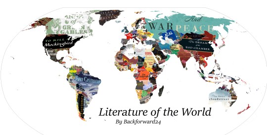
16. One country – one book
The idea is simple – and simply stunning. This literary map does not describe a city or province. It doesn’t describe the country. It describes the entire world!
The map was created by Reddit user Backforward24, and it shows the globe where each country is represented by one book. And the book is represented by its recognizable cover art.
The purpose of the map is not to show the most famous book from the country, but the one that defines this country.
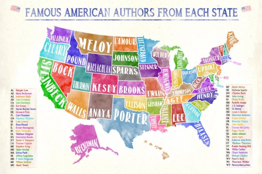
17. Famous American authors from each state
This beautiful watercolor map was created by Jeanne Stevenson, a designer and photographer from Charleston, West Virginia. It picks up one famous author for one US state.
You may disagree with the choice of authors – and it’s the biggest advantage. The visual can be a great prompt for a book club discussion.
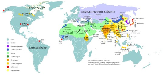
Bonus: Writing systems of the world
There are 10 present-day writing systems in the world: Latin, Cyrillic, Hangul, Other alphabets, Arabic (abjad), Other abjads, Devanagari (abugida), Other abugidas, Syllabaries, Chinese characters (logographic).
This Wikipedia chart classifies them and shows regions where particular systems are being used.
• • •
Want to get more posts like this? Please subscribe by RSS or email. Let’s also connect on Facebook, Twitter, and Pinterest.
Recent lists on Ebook Friendly:
[ef-archive number=5 tag=”lists”]

